The research was performed by a total of four institutions and included the study of complex geological, petrological and petrophysical characteristics, the determination of the basic hydrogeological parameters of the groundwater, the spectral analysis of drill cores, seismic monitoring, the determination of the transport characteristics of the rock and analysis of the geomechanical and geotechnical parameters of the rock massif. 3D structural-geological and geomechanical models of the Bukov URF were then created based on the integration of the wider set of geological data available. The research work provided the comprehensive information necessary for the subsequent performance of experiments focusing on the long-term safety and technical feasibility of the future Czech DGR. In addition, the research work enabled the collection of valuable data only a short time following the excavation of the rock mass.
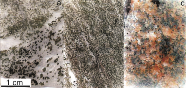
The research results suggest that the facility is situated in a homogenous complex of metamorphic rocks - migmatites, migmatised paragneisses and amphibolites, which have been affected by the typical brittle and ductile deformation events that are observed in other similar rock complexes throughout the Czech Republic. The research included the study of the various alteration products and venous fillings as well as the nature of brittle deformations. The age of the rock environment was estimated at 340 million years (Ma) with the major brittle structures exhibiting age ranges of 287 to 307 Ma and 250 to 256 Ma. The fractures and faults are principally filled with the following minerals: calcite, chlorite, hematite, mica, kaolinite, smectite and illite.
The hydrogeological research included work on both the surface of the site and in the underground workings. Data obtained from the surface measurements were used for the correlation of the hydrogeological data from the underground spaces. The hydrogeological monitoring network contained 3 monitored boreholes, 6 surface springs and 36 underground monitoring points. A hydrogeochemical study subsequently served to clarify the composition, origin and age of, as well as the relationships between the types of water present at the site.
The hydrogeological research provided a range of important information on the character, flow and chemical composition of the groundwater, and how it evolved over time in the fractured environment of hard rock masses at depths corresponding to those of the planned DGR.
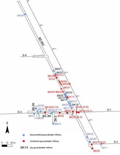
A hydrogeological monitoring network was set up to allow for the long-term monitoring of the groundwater regime in the vicinity of the Rožná mine workings. The underground water regime at the site was found to be unstable and to have been subjected to significant changes over time. Generally speaking, during the excavation and construction of the Bukov URF the groundwater inflow yield declined, with some inflows decreasing slowly (a 25% reduction in the original yield value over three years) and others significantly more rapidly (an 80% decrease in the original value).
The hydrogeological characterisation of the site also allowed for the description of general trends in the development of the chemistry of the groundwater in the crystalline rocks of the Bohemian Massif. The shallower parts of such rocks feature naturally-occurring groundwater of the Ca-HCO3 type, whereas Na-HCO3-type groundwater prevails in the deeper parts. The depth interface between the two groundwater types occurs at a depth of around 600 m (12th level, the location of the URF) with concern to the Rožná mine. Due to oxidation during excavation, the ratio of sulphates to carbonates in the groundwater changed in favour of sulphates, with the extent of the change depending on the geological conditions of the mine workings (e.g. the presence and abundance of pyrite) and the character of the specific inflow. In the geologically varied environment of the Rožná deposit, no groundwater of the Ca-HCO3 type was discovered in the mine workings (except for the newly-excavated Bukov URF); only groundwater of the Ca-SO4 type was recorded. The results of the research on the origin and age of the water, based on the determination of the concentration of tritium, freons, and stable isotopes of oxygen, hydrogen and sulphur in the water at the Bukov URF indicate a mixture of water from 200 to 9000 years old.
Drill cores from selected exploratory boreholes were subjected to scanning and hyperspectral analysis, which resulted in the identification of the basic minerals present, zones of increased alteration, mylonitic zones and the frequency of brittle deformation. Spectral analysis was also performed on borehole half-cores employing image analysis with respect to the radiance and reflection of the given minerals.
The study of the transport parameters of the rock focused on the assessment of rock properties (composition, density, structure) and their influence on the migration of radionuclides in the rock environment, i.e. diffusion and sorption processes. This part of the research investigated the transport properties of the rock environment present at the Bukov URF, which is also found at the Kraví hora and other DGR candidate sites. A series of diffusion tests employing the radionuclides 3H, 36Cl and 125I were performed on the rock samples which was followed by the monitoring of the sorption of selected radionuclides (Cs, Sr, U, Se) on crushed rock samples. The obtained results revealed the very low permeability of the local crystalline rock environment.
This part of the research concerned the determination of the basic geotechnical parameters of the rock environment with respect to both the mine workings and exploration boreholes. Furthermore, the mechanical, material and technological properties of the underground and surface rocks were also determined, and the behaviour of the mine reinforcement bolts verified. The samples used in the tests were taken from the excavated rock material, boreholes and surface outcrops. The quality of the rock mass was determined on the basis of exploration borehole cores (RQD index) as well as via the determination of the RMR and Q rock classification indexes. According to the RMR classification, a substantial proportion of the assessed profiles of the URF mine workings fall under the “good” rock mass quality category.
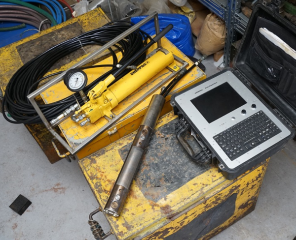
The aim was to obtain information on the stress state and deformation behaviour of the rock mass by means of in-situ measurement. The data obtained was then used for the assessment of rock mass quality and the determination of both deformations of the underground mine workings and induced stress within the rock mass during the construction of the underground laboratory. The measurement of the stress state was conducted via the hydraulic fracturing of the borehole walls (hydro-fracturing). This method allows for the direct measurement of stress in areas around existing boreholes and serves for determining both the size and orientation of the principal stresses.
Further analysis of the stress state of the rock mass, which enabled the determination of the total stress tensor and the monitoring of changes thereof related to anthropogenic intervention in the rock mass, was conducted in boreholes employing a special cone strain gauge probe
Convergence and strain gauge measurements were taken repeatedly at four measurement stations installed during the construction of the URF. The objective of the repeated convergence and strain gauge measurements consisted of the time-spatial assessment of the development of the mutual interaction of the rock mass in the vicinity of the excavated underground openings of the laboratory. The convergence method is based on the accurate measurement of the spacing between installed points along convergence profiles.
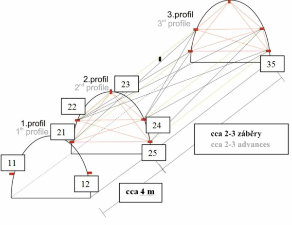
The convergence measurements indicated that, in the case of laboratory workings with a profile of 9.2 m2, the average convergence values were approximately -1.5 mm (with a maximum of -2.5 mm) and, with respect to workings with a profile of 14.5 m2, the maximum convergence values reached up to -6.0 mm, with an average measurement value of around -3.0 mm.
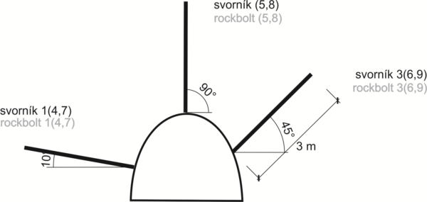
The strain gauge measurements were taken by means of rock bolts fitted with strain gauge sensors, which monitored changes in the load acting upon them.
The purpose of seismic measurements was to determine the magnitude of the vibrations (maximum vibration velocity values) caused by the excavation of the URF workings on the 12th level of the Rožná mine. Digital seismic equipment installed on the 9th level of the Rožná mine in the vicinity of the B1 shaft was employed for measurement purposes.
A 3D structural geological model was subsequently created based on the various methods applied. The model considered 2 levels:
Aimed at improving the assessment of the geological conditions, a 3D model of the surroundings of the Bukov URF was created based on newly-acquired data from the underground complex, archive data and the newly-compiled geological map. The entire underground area of the facility was visualised in 3D using a laser scanner and underground documentation on the lithology, structures, boreholes, samples and monitoring network points.
A 3D geomechanical model of the Bukov URF was compiled on the basis of the 3D structural-geological model and the other data obtained. The model was designed for the conducting of numerical analysis with the aim of assessing the influence of the underground working on the stability of the rock mass as well as for the determination of the range of probable deformation initiated by the excavation work.
Comparison between the results of the numerical analysis and those of the convergence measurements revealed a good match between the calculated and measured deformations of the rock environment.


